The selection of an appropriate mitigation structure depends directly on the type and magnitude of the predicted impact. It should be based on the environmental baseline assessment, on the compatibility between the species to be protected and the characteristics of the planned structures, and on whether implementation costs are reasonable in relation to the expected environmental benefit. Adapting existing or multi-use structures (such as bridges and culverts) is often a feasible and less costly alternative than installing a structure exclusively for wildlife and should therefore be considered first (CALTRANS 2009). The dimensions and spacing of wildlife crossings should account for the characteristics of the target group(s) and surrounding habitats. Smaller structures may meet the needs of small animals; a combination of different types of structures placed relatively close together tends to benefit a larger number of species; and larger, more widely spaced structures may be appropriate for larger animals. BISSONETTE & ADAIR (2008) and BISSONETTE & CRAMER (2008) suggest that, for large mammals, the ideal spacing between wildlife crossings in sensitive areas should correspond to the linear dimension of the home range (the square root of home-range area) of the target species.
Another essential factor when selecting a mitigation structure is the technical feasibility of installation. Roads occupy one of four basic topographic settings: level or riparian terrain, hillside or cut/fill, valley, or elevated terrain (Figure 90). Some structures may not be feasible under particular topographic conditions.
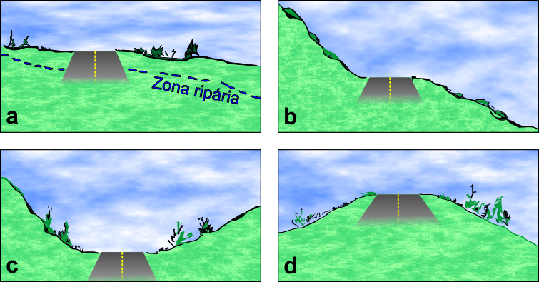
Road sections on level terrain allow the installation of most types of wildlife crossings. In some cases, the road grade* must be raised so that underpasses are not positioned substantially below the surrounding terrain; conversely, the grade may need to be lowered for the installation of overpasses. Valley sections are particularly suitable for overpasses, whereas elevated sections or embankments facilitate the installation of all types of underpasses. Hillside and cut/fill sections are the most difficult settings for wildlife crossings; fencing may therefore be used to guide animals toward locations where the topography provides suitable installation conditions (CLEVENGER & HUIJSER 2011). However, topographic configurations of this type have been associated with lower wildlife-vehicle collision risk (BORKOVCOVÁ et al. 2012) than level terrain. Curved road sections, because of reduced visibility and consequently shorter reaction times for both drivers and wildlife, tend to have higher collision rates (GRILO et al. 2011).
Many factors can influence the use of crossing structures, and the strength of the response depends on the species or animal group considered. Human presence (CLEVENGER & WALTHO 2000) and high noise levels (CLEVENGER & WALTHO 2005) are generally negative for animal groups, whereas structural characteristics such as openness ratio and substrate, as well as features of the adjacent habitat, can have different effects. Large mammalian predators tend to use narrower crossings with greater vegetation cover more intensively, while herbivores (potential prey) tend to prefer crossings with a greater openness ratio and less vegetated surroundings, which provide better visibility and a greater opportunity to respond to potential attacks (CLEVENGER & WALTHO 2005).
This response pattern was observed in studies conducted in North America and should therefore be tested in other regions, communities and species. Animals may also become accustomed to structures over time, changing the magnitude of their responses to these factors; long-term monitoring is therefore necessary for a reliable assessment. Lighting and good air circulation are additional characteristics that positively influence the use of wildlife crossings (CAIN et al. 2003).
In any case, the existence of different response patterns indicates that providing structures with varied characteristics can accommodate a broader range of behavioral patterns and therefore a greater number of species, increasing landscape connectivity.
*Road grade is the longitudinal profile line of the roadway in relation to the terrain, indicating where soil must be cut or filled.
Translation note: This English version was preliminarily translated using ChatGPT and has not yet undergone human review.