Several methods can be used to estimate reductions in mortality, the degree of use of wildlife crossings, species movement patterns, and wildlife diversity and/or abundance in habitats adjacent to roads. Common approaches include roadkill counts, direct visual observations, live-capture traps, track stations, camera traps, hair traps, radio or satellite telemetry, and genetic identification of individuals and species. Depending on the monitoring objective, one or more techniques may be used simultaneously. Whenever the selected method involves the capture, collection or transport of wild-fauna specimens, the appropriate authorization must first be obtained from the environmental licensing authority.
Regardless of the method selected, an Before–After–Control–Impact (BACI) experimental design should be adopted whenever possible. BACI provides strong inferential power for assessing anthropogenic impacts by helping distinguish treatment effects—such as road paving or the installation of a mitigation structure—from other sources of variation (CLEVENGER 2005; ROEDENBECK et al. 2007). This design improves the assessment of mitigation effectiveness and the magnitude of road impacts, including population-level effects (FAHRIG & RYTWINSKI 2009), and allows changes through time to be evaluated. Monitoring should therefore be designed before construction begins (LESBARRÈRES & FAHRIG 2012), because data must also be collected during the pre-impact period.
The sampling design should minimize the influence of variables external to the road context, such as differences in land use and surrounding human disturbance. Under a BACI design, impacted sites (I) are compared with unaffected control sites (C), both before (B) and after (A) the impact. Replication is required in space—multiple impacted and control sites—and in time—multiple sampling occasions before and after the impact. When a complete BACI design is not feasible, for example during the regularization of an existing road for which pre-construction data do not exist, control-versus-impact or before-versus-after designs may be used, although with lower inferential power. In some cases a complete BACI design can still be applied to evaluate newly implemented mitigation measures, using comparable untreated sites as controls. A BDACI design additionally evaluates the period during road construction and can help identify reversible effects such as those caused by noise and machinery movement.
Maintaining connectivity for fish fauna requires specific mitigation measures, as briefly discussed under 2.1. Modified culverts. Monitoring impacts and mitigation effectiveness for fish should likewise use appropriate techniques and equipment, such as nets, hand nets and cast nets, to assess abundance, diversity and population structure upstream and downstream of road structures.
For terrestrial fauna, several monitoring methods can provide information on species presence and identification, attempted crossings, relative abundance, successful crossings, habitat fragmentation, movement patterns, habitat selection and use, and home-range definition. These approaches are summarized in Table 6 and described in the sections below.
| Method | Presence | Identification | Crossing | Abundance | Fragmentation | Movement | Behavior | Habitats | Home range |
|---|---|---|---|---|---|---|---|---|---|
| Roadkill rate | ✓ | ✓ | ✓ | ✓ | |||||
| Camera and video traps | ✓ | ✓ | ✓ | ✓ | ✓ | ✓ | |||
| Live-capture traps | ✓ | ✓ | ✓ | ✓ | ✓ | ✓ | |||
| Track stations | ✓ | ✓ | ✓ | ✓ | ✓ | ||||
| Direct visual observations | ✓ | ✓ | ✓ | ✓ | ✓ | ✓ | |||
| Genetic tools | ✓ | ✓ | ✓ | ✓ | ✓ | ✓ | ✓ | ||
| Hair traps | ✓ | ✓ | ✓ | ✓ | ✓ | ||||
| Radio or satellite telemetry | ✓ | ✓ | ✓ | ✓ | ✓ | ✓ |
Roadkill rate
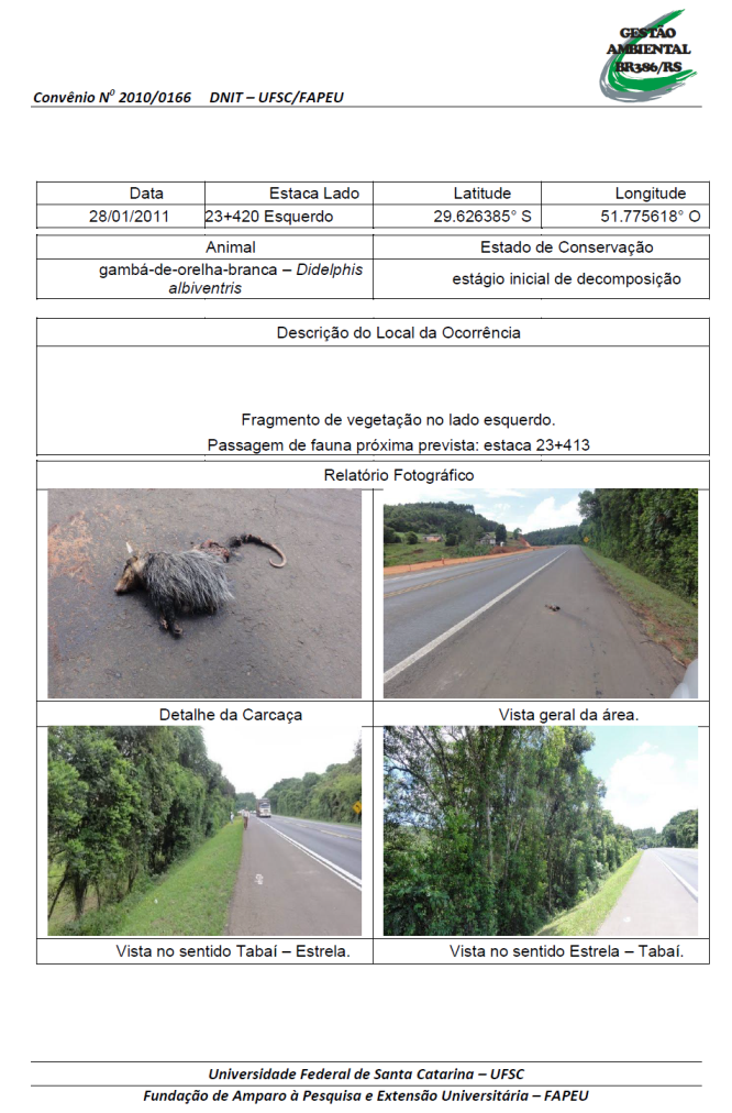
Roadkill frequency is estimated by counting carcasses along the road segment under study. The most common procedure is to survey the segment by vehicle at approximately 50 km/h, with one or two observers visually searching for road-killed animals. Each record should include species identification, photographs and precise GPS coordinates; kilometer posts alone are too imprecise for robust spatial analyses.
Whenever possible, additional variables should be recorded, including surrounding habitat and vegetation condition, season, date and time, weather, type and condition of remains, sex, body size, approximate age, presence of young and evidence of lactation. These variables can help explain collision patterns and refine the characterization of affected groups. Data should follow at least the standards required by the licensing authority and should preferably be stored in standardized spreadsheet/database formats.
Once incorporated into a georeferenced database, records can be mapped and analyzed together with vegetation, topography, land use and other spatial layers. Standardized GIS-compatible databases facilitate the identification of roadkill hotspots and the relationship between mortality, wildlife crossings and landscape characteristics.
Reliable estimates of roadkill frequency must account for methodological and ecological sources of bias. Observer detection ability varies, so the same trained personnel should be used whenever possible. Vehicle-based detection should be calibrated against walking surveys on subsamples of the same segments. Carcass persistence and removal by scavengers or road-maintenance activities can substantially reduce detectability and must be considered when defining survey duration, sampling frequency and correction factors.
Sampling frequency also affects estimates of species richness and mortality. Short-lived carcasses and small-bodied animals are particularly likely to disappear between surveys. Therefore, survey schedules should be selected according to the target taxa, objectives and expected persistence rates, with correction factors used when appropriate.
|
Figure 93. Roadkill record form used during monitoring of the BR-386/RS duplication works, Tabaí–Estrela segment (DNIT-UFSC/FAPEU 2011). |
|
|
| Figure 94. Raw-data recording sheet templates proposed by IBAMA (2011). |
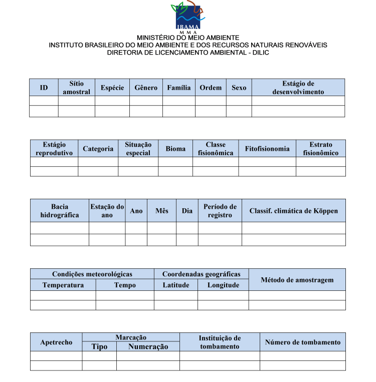
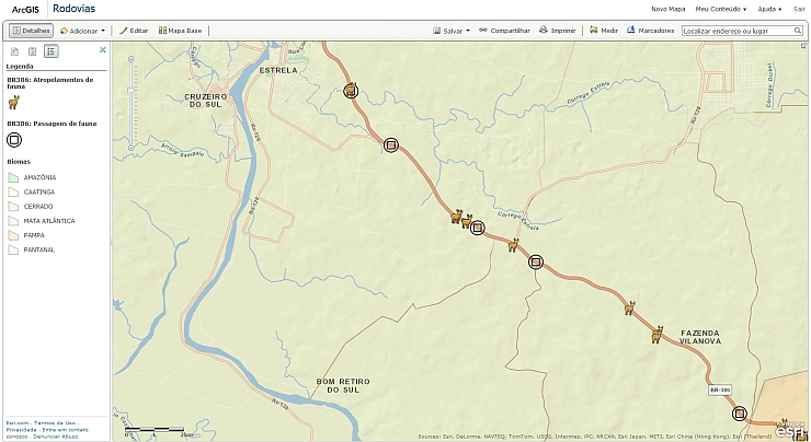 Figure 95. Example of a Geographic Information System created from georeferenced roadkill-monitoring data from BR-386/RS. Additional information layers may be added as required for the assessment. |
|
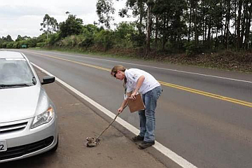
Figure 96. Removal of a road-killed animal from the roadway during environmental monitoring (DNIT-UFSC/FAPEU 2011). |
|
Figure 97. Road-killed capybara, BR-471 – Taim Ecological Station/RS. Photo: Antonio Tolentino Piau/DNIT. |
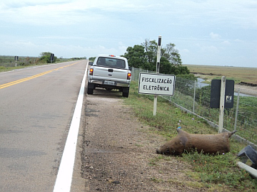
BAGER & DA ROSA (2011) tested different sampling frequencies (weekly, twice weekly, monthly, every two months, and quarterly) to determine the sampling effort needed to estimate wildlife species richness in the surrounding area using roadkill records. With the exception of birds, for which even weekly surveys over two years failed to adequately represent known diversity, twice-weekly surveys adequately represented amphibian, reptile, and mammal communities. In the context of environmental licensing, however, the primary purpose of this type of survey is to identify roadkill hotspots rather than to estimate species richness, which is assessed using specific methods within the directly affected area. The authors’ findings therefore suggest that even quarterly surveys are sufficient to identify the species most frequently killed on roads. Given that a large proportion of carcasses are removed within 24 hours of a collision (TEIXEIRA 2011), and that longer intervals between sampling days increase the uncertainty associated with the correction factors used, quarterly sampling campaigns lasting 10 days are recommended for most situations.
Camera and video traps
Camera and video traps are commonly used to document medium- and large-bodied species using wildlife crossings and to assess wildlife diversity and relative abundance in habitats within the road influence area. Most units are triggered automatically by infrared sensors and can operate continuously during day and night.
Compared with direct observation, these devices can remain deployed for long periods without an observer and provide temporal and behavioral information on wildlife movement. Their effective detection range is limited, so they are especially useful at confined locations such as trails, water points, culverts, small bridges, bridges and crossing structures. Equipment costs have declined, although theft and vandalism remain practical concerns.
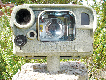 Figure 98. Camera-trap device. Photo: www.faunatech.com.au. |
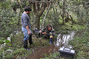 Figure 99. Technician installing a camera trap, BR-392/RS. Photo: DNIT / STE - Serviços Técnicos de Engenharia S.A. |
|
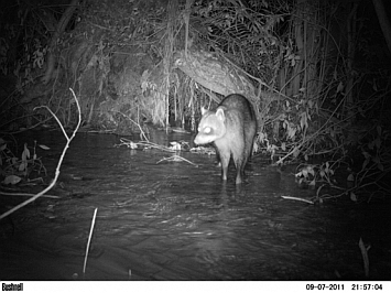 Figure 100. Night image of a crab-eating raccoon (Procyon cancrivorus) recorded by a camera trap within the BR-392/RS influence area. Photo: DNIT / STE - Serviços Técnicos de Engenharia. |
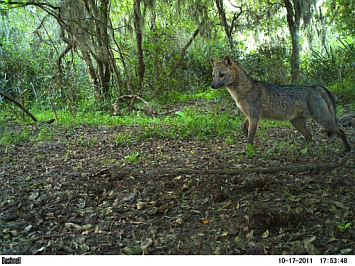 Figure 101. Crab-eating fox (Cerdocyon thous) recorded by a camera trap during BR-392/RS implementation monitoring. Photo: DNIT / STE - Serviços Técnicos de Engenharia. |
|
Live-capture traps
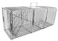
This traditional method for studying small mammals has gradually become less common as less invasive techniques have developed. Nevertheless, when combined with marking and capture–recapture approaches it can provide valuable information on population density and movement between habitats adjacent to roads.
Because the method is labor-intensive, the number, arrangement and deployment time of traps must be standardized among sampling units. Pitfall traps are particularly useful for small animals and relative-abundance comparisons, but require daily inspection. When combined with drift fences they are effective for amphibians, some reptiles and small rodents.
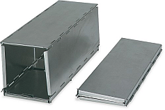 Figure 102. Sherman trap. Photo: www.livetrap.com. |
|
Figure 103. Tomahawk trap. Photo: www.livetrap.com.
|
|
Figure 104. Pitfall traps with drift fences. Photo: David A. Pike, www.jcu.edu.au.
|
Track stations
Track stations, including sand boxes placed at wildlife-crossing entrances or longer tracking strips parallel to roads, can document animal passage. They can be used to estimate use of crossing structures and successful road crossings before and after road works, providing information on structure effectiveness and road avoidance.
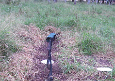
Continuous tracking strips along road shoulders, using natural or artificially prepared substrates, can identify locations where animals successfully cross the road and provide estimates of relative abundance, provided they are regularly inspected and restored. This low-cost method is suitable for a wide range of terrestrial vertebrates. Untreated natural substrates, especially along watercourses and trails, can also provide valuable evidence of species presence—not only through footprints, but also through signs such as feces and even the characteristic odors of certain animals, including capybaras (Hydrochaeris hydrochaeris), foxes (Pseudalopex gymnocercus and Cerdocyon thous), and hog-nosed skunks (Conepatus chinga).
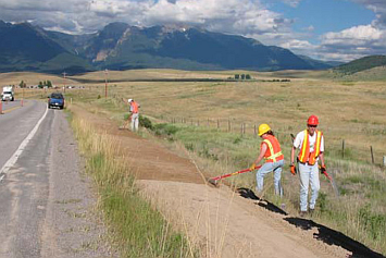 Figure 105. Continuous track station along the road shoulder (Caltrans 2009). |
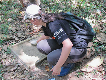 Figure 106. Track station: sand box. Photo: www.seaembu.org. |
|
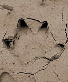 Figure 107. Capybara track (Hydrochaeris hydrochaeris) (Carvalho & Luz 2008). |
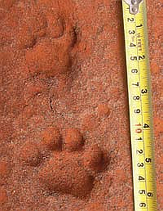 Figure 108. Ocelot track (Leopardus pardalis) (Carvalho & Luz 2008). |
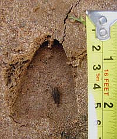 Figure 109. Red brocket deer track (Mazama americana) (Carvalho & Luz 2008). |
||
Direct visual observations
Direct observation is one of the most traditional and widely used wildlife-monitoring methods, allowing relatively rapid surveys over large areas at low cost. It provides essential information on species presence and behavior, including responses to roads and wildlife crossings. Standardized transects and observation periods permit quantitative comparisons. Night surveys using spotlights can be particularly effective for medium and large mammals. Specialized techniques may be required for species occupying unusual habitats, such as cliff-dwelling amphibians.
BERGHELLA & CANDIDO 2011Genetic tools
Genetic monitoring approaches have also been proposed. BALKENHOL & WAITS (2009) and SIMMONS (2010) review studies that have used molecular biology techniques to assess road impacts and suggest approaches at multiple levels of biological organization, from genes to landscapes. Information on population genetic variability, estimates of gene flow, the effective number of migrants, and effective population size (KELLER & LARGIADÈR 2003; KELLER et al. 2005) can, particularly when combined with more traditional methods, help clarify the ecological consequences of road-related barrier effects and mortality.
These approaches, however, require long periods to detect potential changes (CORLATTI et al. 2009). Samples can be collected using non-invasive techniques, such as feces collected from the ground (EPPS et al. 2005) or hair collected using hair traps (CLEVENGER & SAWAYA 2010).
Hair traps
Hair traps, often constructed with strands of barbed wire, can help evaluate the use of crossing structures by medium and large mammals, particularly threatened species that are difficult to monitor by other methods. Correct species identification requires trained personnel. Collected hair may also support genetic analyses and even individual identification, although this substantially increases costs. This approach is especially valuable for monitoring the presence and movement of conservation-priority species.
CALTRANS 2009Radio or satellite telemetry
Radio or satellite telemetry allows researchers to assess animal home ranges, identify road-crossing locations and evaluate behavioral responses to roads and mitigation structures. It is most often used for larger animals and conservation-priority species, but declining costs and equipment miniaturization are expanding its use to smaller species, including turtles.
BEAUDRY et al. 2010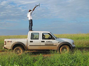 Figure 110. Telemetry tracking. Photo: Adriano Gambarini - ICMBio. |
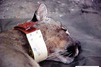 Figure 111. Female puma fitted with a radio collar. Photo: Peter G. Crawshaw Jr. |
|
Translation note: This English version was preliminarily translated using ChatGPT and has not yet undergone human review.