1.2. Environmental baseline assessment
By definition, some degree of environmental impact will always occur, even when the road alignment has been selected as carefully as possible. Environmental managers must therefore assess whether structural adaptations or management measures are needed within the area of influence to maintain connectivity. Knowledge of local biodiversity, animal movements and the corridors used by resident species is essential for deciding whether structures are needed and, if so, which types should be installed.
To define appropriate mitigation measures, the baseline assessment must also identify the characteristics of the biological communities involved and the potential impact generated by construction of the road. If the principal impact is mortality, measures designed to prevent wildlife–vehicle collisions will generally be most appropriate. If the barrier effect is more important for priority groups in the region, structures that facilitate movement will be preferable. In many situations, a combination of both approaches produces the best results (Ahern et al. 2009).
Roedenbeck et al. (2007) identify five key questions in road ecology: (1) Under what circumstances do roads affect population persistence? Most studies document road mortality or effects on animal movement but do not permit robust inference about population viability. Because responses vary among species and environments and require substantial sampling effort, licensing studies should focus this type of investigation on species of particular relevance to each context, progressively accumulating information for future assessments. (2) What is the relative importance of road impacts to population persistence? Given the diversity of human pressures on wildlife, experimental designs should distinguish road effects from other sources of mortality and habitat change. (3) How can the cumulative effects of road networks be assessed? Analyses should move beyond isolated road segments and consider network-level fragmentation and regional land-use change. (4) Under what circumstances can mitigation measures reduce road impacts? The effectiveness of structures and management measures depends on species, landscape, traffic and design, and therefore requires monitoring. (5) How can road planning be improved to avoid impacts before they occur? Strategic planning and early comparison of alternative alignments offer the greatest opportunity to prevent impacts rather than merely mitigate them after project definition.
A Geographic Information System (GIS) is especially useful for integrating the spatial information required for this assessment. Overlaying the proposed alignment with aerial imagery, topography, hydrography, conservation-priority areas, native vegetation remnants, roadkill records, protected areas, agricultural potential and urban areas can reveal sensitive sectors and support the preliminary location of fencing, wildlife crossings and other mitigation measures (Figure 5).
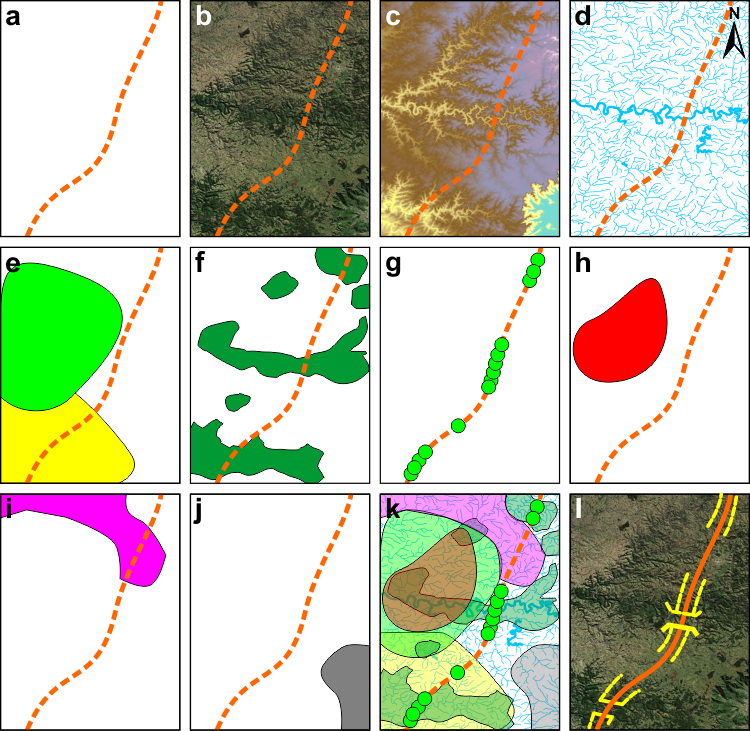
Figure 5. Examples of information layers useful in a GIS for identifying priority areas for maintaining connectivity: (a) proposed alignment, (b) aerial imagery, (c) elevation, (d) hydrography, (e) conservation-priority areas, (f) native vegetation remnants, (g) roadkill records, (h) protected areas, (i) agricultural potential, and (j) urban areas. In (k), geoprocessing and integrated analysis; in (l), proposed mitigation measures (fencing and wildlife crossings).
In addition to the potential distribution of species within the project’s area of influence, obtained from review of existing information, two types of wildlife data are commonly generated in environmental licensing studies in Brazil: qualitative surveys of fauna in the area directly affected by the project (often 500 m on each side of the road axis) and quantitative surveys of road mortality along an existing alignment. Combining these data with analysis of the landscape crossed by the road provides a basis for identifying sites of interest for mitigation.
This is a conservative approach, perhaps strongly grounded in the precautionary principle, because it does not by itself provide enough information to estimate the effect of the road on target-species populations, the intensity of the barrier effect on biological cycles, or the amount of available home range. In countries such as the United States, simply demonstrating road mortality or a barrier effect, without information indicating the significance of those impacts, may not be considered sufficient to require mitigation (Caltrans 2009). Continued monitoring of biodiversity and, particularly, road-mortality frequency is used to evaluate mitigation effectiveness and to support subsequent adjustment through adaptive management, as discussed in Section 3, Monitoring.
Baseline data must also be interpreted in relation to expected traffic characteristics—volume, speed, and daily and seasonal variation—because these strongly influence wildlife behavior (Caltrans 2009). Roads with fewer lanes and intermediate traffic volumes may produce more wildlife–vehicle mortality (Van Langevelde et al. 2009), whereas wide roads with heavy traffic tend to produce stronger avoidance by wildlife (Seiler & Helldin 2006), as illustrated in Figure 6. Estimates of successful wildlife crossings, although rarely available, should be included among baseline objectives because they provide valuable information for assessing both the impact of road widening and the need for and effectiveness of crossing structures. Crossing success can be investigated using methods ranging from simple track beds along road segments to video monitoring and estimates of gene flow (Caltrans 2009).
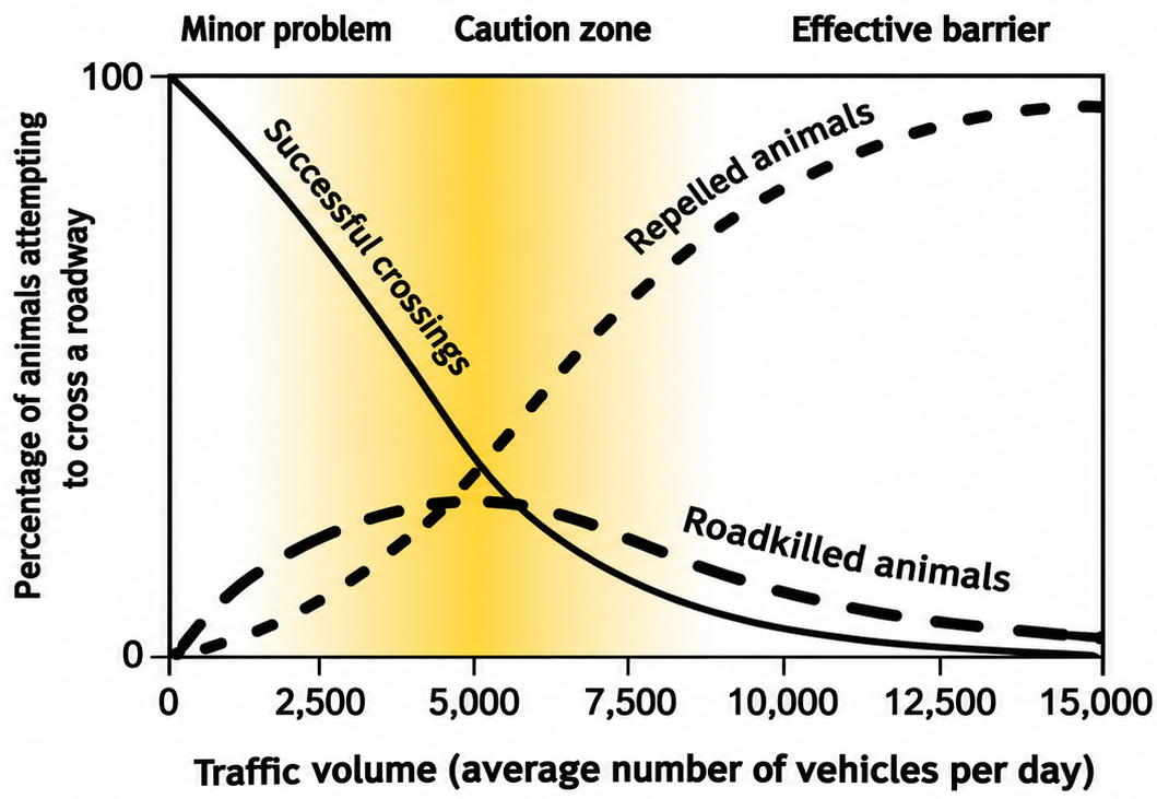 Figure 6. Conceptual model of the effects of traffic on wildlife. Adapted from Seiler & Helldin (2006). |
Although it is difficult to determine the degree of road avoidance by wildlife—individuals that do not attempt to cross—data on road-mortality rates and successful-crossing rates allow a partial estimate of the barrier effect (β). Jaeger & Fahrig (2001) define this effect as the sum of the proportion of individuals that avoid the road (ρ) and the proportion that die while attempting to cross it (κ), as represented in Figure 7. Information on successful crossings can be compared with mortality data to evaluate the need for mitigation aimed at reducing wildlife–vehicle collisions. Road avoidance can be partly mitigated through habitat management as well as through crossing structures.
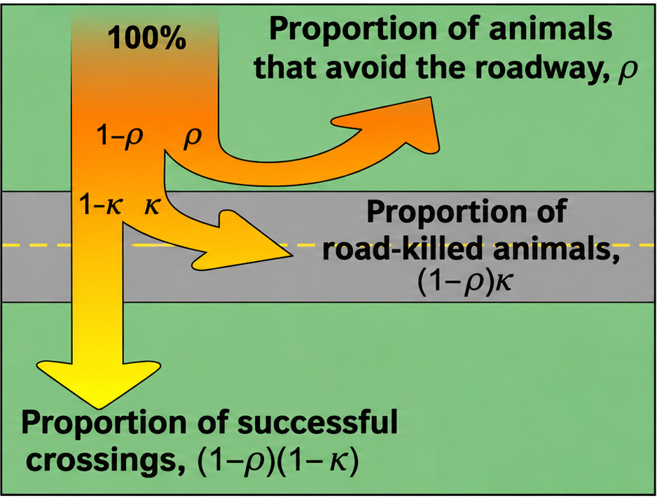 Figure 7. Relationship among components of the barrier effect. Adapted from Jaeger & Fahrig (2001). |
Clusters of wildlife–vehicle collisions can be identified through cartographic analysis of georeferenced records or with specific software such as Siriema (Spatial Evaluation of Road Mortality), developed at UFRGS. Bager & Rosa (2010) propose an index that assigns greater weight to target species—those that are threatened or regarded as important for maintaining ecological processes. This avoids prioritizing a single abundant species or taxon with high roadkill frequency, such as amphibians, at the expense of species with smaller populations but greater ecological importance, such as some mammals.
Target-species identification is still infrequently used in Brazil except in particular situations, although it is a priority in some other countries when deciding whether mitigation is necessary. Even so, the approach commonly used in Brazil—primarily directed toward maintaining connectivity among habitats regarded as important—often benefits a broad spectrum of species and therefore also encompasses many species that might otherwise have been selected as targets. The outcome is similar to the multiple-target-species approach recommended by Beier et al. (2008), in which selected species function as “umbrellas” for other taxa and for ecological processes.
In typical situations, the assessment should therefore include the parameters listed in Table 2. Information on the biology and ecology of target species, however, often requires more time and investment than are available during preliminary environmental licensing in Brazil. Such information can nevertheless be obtained during road operation and subsequently used to reassess mitigation measures.
Table 2. Information to be obtained in the wildlife environmental baseline assessment.
|
Parameter |
Methods |
|
Wildlife diversity |
Literature review. |
|
Identification of threatened species |
Consult threatened-species lists. |
|
Identification of potentially sensitive habitats and future land use: wetlands, forests, riparian corridors and protected areas |
Geoprocessing and field landscape assessment; analysis of master plans and trends in agricultural, urban and industrial expansion. |
|
Identification of current and potential corridors |
Roadkill records; track and/or camera traps; expert assessment; mathematical modeling of habitat use. |
|
Biology and ecology of target species: presence/absence, relative and absolute abundance, mortality rates and habitat fragmentation |
Track and/or camera traps; direct observation; live traps; hair traps; sign analysis (feces and pellets); radio or GPS telemetry. |
The Terms of Reference for environmental studies must therefore specify the information to be obtained in the baseline assessment and the minimum standards or methods to be used, including spatial resolution of imagery, sampling effort, seasonality, statistical analysis, and identification of target species or groups. Once the general situation has been established and sensitive areas and species identified, an ideal second stage would involve more detailed surveys to obtain biological parameters capable of confirming the significance of the potential impact and the appropriateness of proposed measures: confirmation of target-species presence, estimates of relative and absolute abundance, mortality rates, and habitat fragmentation.
Brazilian legislation requires the Environmental Impact Study during preliminary licensing and the Basic Environmental Plan (PBA), which details Environmental Programs, during installation licensing. Consequently, the baseline phase is largely concentrated in preliminary licensing. Both levels of information should therefore be addressed in the EIA, and the Terms of Reference should make the sequential nature of the baseline assessment explicit: more complex biological parameters should be investigated primarily in sensitive areas and for target species identified during the initial assessment.
Because prior information on biological parameters of native Brazilian species is often scarce and licensing schedules are limited, it will usually be impossible to obtain every desirable variable. Methods should therefore be selected according to the best balance among cost, time and information value. Presence/absence and relative frequency, for example, can generally be obtained more quickly than annual mortality rates or measures of population fragmentation (Caltrans 2009). More demanding information can then be incorporated into post-construction monitoring and used to support adaptive modification of mitigation design. Common methods for collecting primary wildlife data are presented in Section 3.1.
Regardless of the methodology adopted, standards for detail and data presentation should progressively converge toward a situation in which different biodiversity information systems can be integrated (Drucker 2011). Minimum metadata should accompany wildlife occurrence records. Because of their volume and broad geographic distribution, data generated through wildlife baseline surveys and monitoring in environmental licensing and road ecology represent a major source of biological and ecological information. Agencies should therefore require raw data in electronic tabular formats together with relevant metadata, allowing these records eventually to be incorporated into relational databases maintained by different institutions and to contribute to a national biodiversity information base.
Translation note: This English version was preliminarily translated using ChatGPT and has not yet undergone human review.